File:Ocean gravity map.gif
From ScoutMedia, the free scout media repository
Size of this preview: 800 × 473 pixels. Other resolution: 1,010 × 597 pixels.
Original file (1,010 × 597 pixels, file size: 466 KB, MIME type: image/gif)
| Description: | |
|---|---|
| Source: | Thank you to edit that page to specify the source of the file. |
| Author: | Thank you to edit that page to specify the author of the file. (If it is your own work (i.e. not a scanning of another image made by you), please sign using the template {{User}} |
| date/time | username | resolution | size | edit summary |
|---|---|---|---|---|
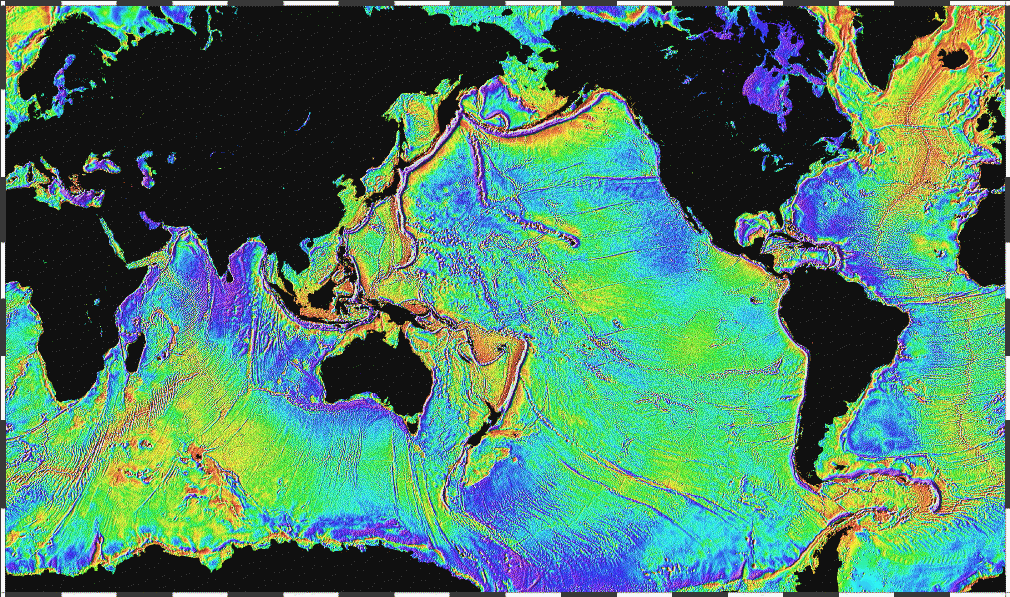
| 2006-04-03T22:18:34Z | Korrigan | 1010×597 | 477666 | Ocean basins mapped with satellite altimetry. Seafloor features larger than 10 km are detected by resulting gravitational distortion of sea surface. Source: http://www.ngdc.noaa.gov/mgg/bathymetry/predicted/explore.HTML {{PD-USGov-DOC-NOAA}} [[Cate |
| 2006-03-19T20:36:46Z | Maksim | 1010×597 | 200309 | La bildo estas kopiita de wikipedia:en. La originala priskribo estas: Ocean basins mapped with satellite altimetry. Seafloor features larger than 10 km are detected by resulting gravitational distortion of sea surface. Source: http://www.ngdc.noaa.go |
File history
Click on a date/time to view the file as it appeared at that time.
| Date/Time | Thumbnail | Dimensions | User | Comment | |
|---|---|---|---|---|---|
| current | 22:02, 25 March 2015 | | 1,010 × 597 (466 KB) | Egel (talk | contribs) | This image was copied from commons:commons. The original description was: {{Information |Description = {{en|Ocean basins mapped with satellite altimetry. Seafloor features larger than 10 km are detected by resulting gravitational distortion of sea s... |
You cannot overwrite this file.
File usage
There are no pages that use this file.
Global file usage
The following other wikis use this file:
- Usage on en.scoutwiki.org

